The National Hurricane Center is tracking three systems over the Atlantic and Gulf of Mexico Monday, including one tropical storm, one tropical depression, and a tropical cyclone.
Here's the latest update from the NHC as of Sept. 22.
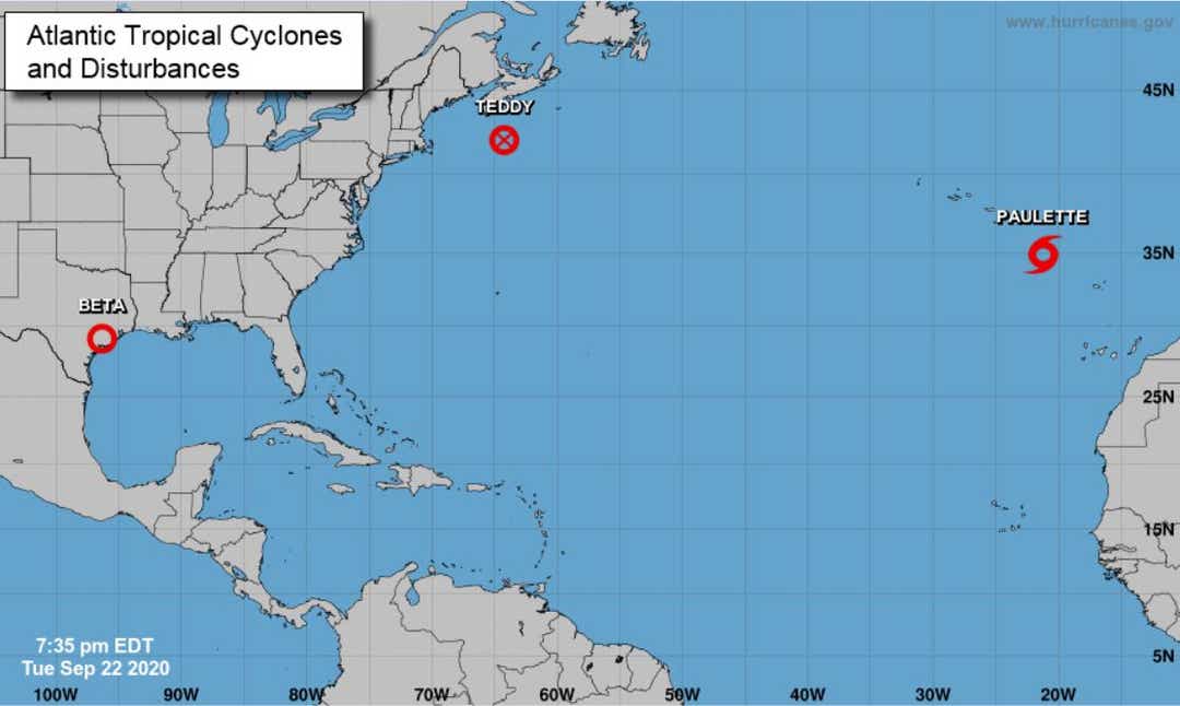
What's out there and where are they?
Post Tropical Cyclone Teddy is 190 miles south of Halifax, Nova Scotia.
Tropical Depression Beta is 40 miles north of OConnor, Texas.
Tropical Storm Paulette is 390 miles southeast of the Azores.
More: One year after Hurricane Dorian's close call, the Treasure Coast reckons with what could've been ... and what will be
More: High tides and strong winds damage shoreline and bring rough seas to Treasure Coast
How likely are they to strengthen?
Post Tropical Cyclone Teddy: Although further weakening is likely tonight and Wednesday, Teddy should be a strong post-tropical cyclone when it moves near and over Nova Scotia.
Tropical Depression Beta: Maximum sustained winds have decreased to near 30 mph with higher gusts. Gradual weakening is forecast through Friday, and Beta is expected to become a remnant low pressure system by late Wednesday.
Tropical Storm Paulette: Maximum sustained winds are near 40 mph with higher gusts. Slow weakening is forecast, and Paulette is expected to become a remnant low by Wednesday morning.
Details on named storms
Post Tropical Cyclone Teddy
- Location: 190 miles south of Halifax, Nova Scotia
- Maximum sustained winds: 85 mph
- Present movement: North-northwest at 18 mph
Tropical Storm Beta
- Location: 40 miles north of Port OConnor, Texas
- Maximum sustained winds: 30 mph
- Present movement: Northeast at 5 mph
Tropical Storm Paulette
- Location: 390 miles east-southeast of the Azores
- Maximum sustained winds: 40 mph
- Present movement: East at 12 mph
Who is likely to be impacted?
Post Tropical Cyclone Teddy
Tropical storm conditions are occurring in the Nova Scotia warning area now and are expected to begin in the Newfoundland warning area Wednesday afternoon.
Through Thursday, Teddy is expected to produce rainfall accumulations of 2 to 4 inches with isolated totals of 6 inches across sections of Atlantic Canada.
Tropical Depression Beta
For the middle and upper Texas coast, additional rainfall of 4 to 8 inches with isolated storm totals up to 20 inches is expected. Significant flash and urban flooding is occurring and will continue today.
Rainfall totals of 13 to 14 inches have been measured across portions of the Houston metropolitan area thus far.
Tracking the tropics in real time
Watches/warnings issued
Post Tropical Cyclone Teddy
A Tropical Storm Warning is in effect for:
- South coast of Nova Scotia from Digby to Meat Cove
- Port aux Basques to Francois Newfoundland
A Tropical Storm Watch is in effect for:
- Meat Cove to Tidnish Nova Scotia
- North of Digby to Fort Lawrence Nova Scotia
- Magdalen Islands Quebec
- Prince Edward Island
tinyurlis.gdclck.ruulvis.netshrtco.de
مقالات مشابه
- بررسی 2: چگونه از امن آیا شما احساس می کنید در حال حاضر به عنوان بیشتر از فلوریدا بازگشایی?
- شاستا گزارش پنج COVID-19 نفر از دوشنبه; Tehama 18 بیشتر
- آموزش صفر تا صد زبان انگلیسی
- مدیران ورزشی و مربیان در حال نا امید با ULTIMOPREZZO رهبری است. آن را منجر به مدارس ترک ؟
- مغلوب ساختن پیشی جستن به منظور نشانه اولویت بندی مهارت های شغلی بیش از مدرک دانشگاهی در دولت استخدام
- میامی دلفین ها نمی تواند عمل تا پورت سنت لوسی گراد آلبرت Wilson طول می کشد تا, دوچرخه سواری بر خیریه
- آزمون آنلاين آيين نامه راهنمايي و رانندگي
- پارچه گوشه استوارت در ورو بیچ به بعد از سال 72 با توجه به COVID-19
- کربن فعال شده گرانول | بهترین سایت
- کفش ورزشی و باشگاه - آفلند